
Here’s a look at MesoScan Radar and Live Temperatures across North Texas.
DFW thru sunrise… Cloudy. Lows in the mid 60s. Northwest winds around 5 mph.

Here’s a look at MesoScan Radar and Live Temperatures across North Texas.
DFW thru sunrise… Cloudy. Lows in the mid 60s. Northwest winds around 5 mph.

William’s North Texas Hazardous Weather Forecast this Evening:
No hazardous weather is expected at this time.
DFW Tonight Mostly cloudy. Lows in the mid 60s. North winds around 5 mph. -William

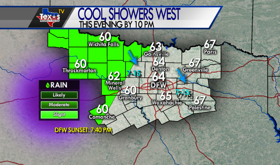
Expect a cool and cloudy evening across North Texas. A few showers remain possible in our Western Counties.
Here’s a look at Live Temperatures across North Texas, MesoScan Radar and the Updated Forecast Map.
DFW thru 5 pm this afternoon… Cloudy with a less than 20 percent chance of showers. Much cooler with highs in the upper 60s. Northwest winds 5 to 10 mph. -William


Here are Thursday’s Live Lake Levels across North Texas.

From the National Hurricane Center:
For the North Atlantic Caribbean Sea and the Gulf of Mexico: The National Hurricane Center is issuing advisories on Tropical Storm Paulette, located over the central tropical Atlantic, and on Tropical Storm Rene, located over the eastern tropical Atlantic. A trough of low pressure located just off the coast of North Carolina is producing minimal shower and thunderstorm activity. This system is expected to move inland over eastern North Carolina thru 5 pm this afternoon…, and therefore significant development is not expected. * Formation chance through 48 hours low near 0 percent. * Formation chance through 5 days low near 0 percent. A large area of disorganized showers and T-Storms centered a couple of hundred miles northeast of the Central Bahamas is associated with a surface trough of low pressure. This system is forecast to move westward, crossing the Bahamas and Florida on Friday and moving into the eastern Gulf of Mexico over the weekend. Upper-level winds are expected to become conducive for some development of this system while it moves slowly west-northwestward over the eastern Gulf of Mexico early next week. * Formation chance through 48 hours low near 0 percent. * Formation chance through 5 days low 30 percent. Another trough of low pressure has developed over the northeastern Gulf of Mexico and is producing a few disorganized showers and T-Storms. Some slow development of this system is possible while this system moves westward and then southwestward over the northern and western Gulf of Mexico through early next week. * Formation chance through 48 hours low 10 percent. * Formation chance through 5 days low 20 percent. A tropical wave is now moving off the west coast of Africa, producing a large area of showers and T-Storms. Gradual development of this system is forecast, and a tropical depression is expected to form by this weekend or early next week while the system moves generally westward across the eastern and central tropical Atlantic. * Formation chance through 48 hours medium 60 percent. * Formation chance through 5 days high 90 percent. Another tropical wave is forecast to emerge off the west coast of Africa this weekend. Environmental conditions are expected to be conducive for development, and a tropical depression could form over the far eastern tropical Atlantic Ocean early next week while the system moves slowly westward. * Formation chance through 48 hours low near 0 percent. * Formation chance through 5 days medium 40 percent. Forecaster Berg
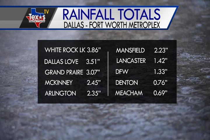
We saw a good soaking rain across the Metroplex yesterday and overnight. Rainfall totals varied dramatically. White Rock Lake in Dallas County was the winner with 3.86″ Denton was on the lower side of things with only .76″.
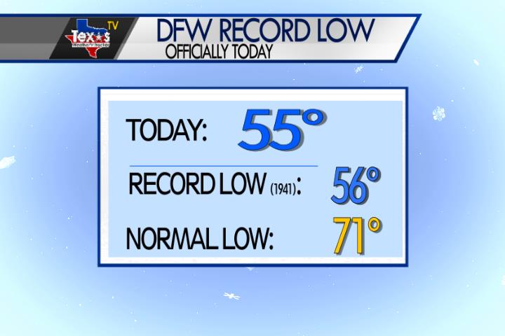
It was a much cooler start to the morning in the Metroplex behind yesterdays cold front. In fact, it was a record cold start to the morning. Officially at DFW the morning low was 55 degrees and that breaks the old record low for today’s calendar date of 56 degrees set in 1941.
William’s North Texas Hazardous Weather Forecast for Thursday:
Scattered showers and occasional T-Storms will continue across much of North and Central Texas this morning and then over western North Texas thru 5 pm this afternoon…. Brief heavy rain which may cause short lived minor flooding is possible. Severe weather is not expected.