
DFW Today Cloudy. A 50 percent chance of showers this morning. Cooler with highs in the lower 70s. Northwest winds 5 to 10 mph. -William
DFW Today Cloudy. A 50 percent chance of showers this morning. Cooler with highs in the lower 70s. Northwest winds 5 to 10 mph. -William

Here’s a look at MesoScan Radar and Live Temperatures across North Texas.
DFW thru sunrise… Showers and perhaps an isolated thunderstorm Much cooler with lows in the upper 50s. Northwest winds around 10 mph. Chance of rain 90 percent.


William’s North Texas Hazardous Weather Forecast this Evening:
Widespread showers and occasional T-Storms will continue across much of North and Central Texas. The most expansive and heaviest rainfall is expected to remain along and east of I-35 this evening, then shift back to along and west of I-35 overnight. Some localized flooding will be the primary concern across this area. Severe weather is not expected.

From William Cole: At 717 PM CDT, MesoScan Radar was tracking a strong thunderstorm near Campbell, or 9 miles east of Greenville, moving north at 25 mph. Penny size hail and wind gusts up to 50 mph will be possible with this storm. Locations impacted include Greenville, Commerce, Cumby, Campbell and Neylandville. Torrential rainfall is also occurring with this storm, and may lead to localized flooding. Do not drive your vehicle through flooded roadways.
Stay with William Cole and Texas Weather Tracker TV for continuing coverage, online, on our app and on TV. Let’s stay safe together.

If you have not already downloaded the Free Texas Weather Tracker TV mobile app – do that now. Search your app store for Texas Weather Tracker TV. Also, add our free Live Channel to your TV through Roku, Apple or Amazon Fire TV streaming players.

Like our forecasts? Love our severe weather coverage? Help support us and local Texas weather coverage. Join our Patreon for $2.99 per month. www.patreon.com/texasweathertrackertv

From William Cole: At 547 PM CDT, MesoScan Radar was tracking a strong thunderstorm near Athens, moving north at 20 mph. Half-inch hail and winds in excess of 40 mph will be possible with this storm. Locations impacted include Athens, Malakoff, Eustace, Caney City, Log Cabin and Murchison. Torrential rainfall is also occurring with this storm, and may lead to localized flooding. Do not drive your vehicle through flooded roadways.
Stay with William Cole and Texas Weather Tracker TV for continuing coverage, online, on our app and on TV. Let’s stay safe together.
If you have not already downloaded the Free Texas Weather Tracker TV mobile app – do that now. Search your app store for Texas Weather Tracker TV. Also, add our free Live Channel to your TV through Roku, Apple or Amazon Fire TV streaming players.
Like our forecasts? Love our severe weather coverage? Help support us and local Texas weather coverage. Join our Patreon for $2.99 per month. www.patreon.com/texasweathertrackertv

From William Cole: A Flood Advisory has been issued for Collin, Dallas, Denton & Tarrant Counties in the Metroplex until 8:45 PM. Ponding on the roadways and localized street flooding is possible.
At 543 PM CDT, MesoScan Radar indicated heavy rain due to T-Storms. This will cause urban and small stream flooding. Areas that are low lying or poor drainage areas will experience minor flooding in the advisory area. Between 1 and 3 inches of rain have fallen.
Remember if you see water across a roadway do not drive through it. Turn Around Don’t Drown.
Stay with William Cole and Texas Weather Tracker TV for continuing coverage, online, on our app and on TV. Let’s stay safe together.
If you have not already downloaded the Free Texas Weather Tracker TV mobile app – do that now. Search your app store for Texas Weather Tracker TV. Also, add our free Live Channel to your TV through Roku, Apple or Amazon Fire TV streaming players.
Like our forecasts? Love our severe weather coverage? Help support us and local Texas weather coverage. Join our Patreon for $2.99 per month. www.patreon.com/texasweathertrackertv
From William Cole: At 513 PM CDT, MesoScan Radar was tracking a strong thunderstorm over Cleburne, moving north at 35 mph. Wind gusts up to 50 mph will be possible with this storm. Locations impacted include Burleson, Cleburne, Crowley, Keene, Joshua, Rendon, Godley, Cross Timber and Briaroaks.
Stay with William Cole and Texas Weather Tracker TV for continuing coverage, online, on our app and on TV. Let’s stay safe together.
If you have not already downloaded the Free Texas Weather Tracker TV mobile app – do that now. Search your app store for Texas Weather Tracker TV. Also, add our free Live Channel to your TV through Roku, Apple or Amazon Fire TV streaming players.
Like our forecasts? Love our severe weather coverage? Help support us and local Texas weather coverage. Join our Patreon for $2.99 per month. www.patreon.com/texasweathertrackertv
DFW Tonight Cloudy with showers and T-Storms likely. Cooler with lows in the lower 60s. North winds around 5 mph. Chance of rain 70 percent. -William

From William Cole: A Flood Advisory has been issued for Dallas & Tarrant Counties in the Metroplex until 6:00 PM. Ponding on the roadways and localized street flooding is possible.
At 406 PM CDT, MesoScan Radar indicated heavy rain due to T-Storms. This will cause urban and small stream flooding. Areas that are low lying or poor drainage areas will experience minor flooding in the advisory area.
Remember if you see water across a roadway do not drive through it. Turn Around Don’t Drown.
Stay with William Cole and Texas Weather Tracker TV for continuing coverage, online, on our app and on TV. Let’s stay safe together.
If you have not already downloaded the Free Texas Weather Tracker TV mobile app – do that now. Search your app store for Texas Weather Tracker TV. Also, add our free Live Channel to your TV through Roku, Apple or Amazon Fire TV streaming players.
Like our forecasts? Love our severe weather coverage? Help support us and local Texas weather coverage. Join our Patreon for $2.99 per month. www.patreon.com/texasweathertrackertv
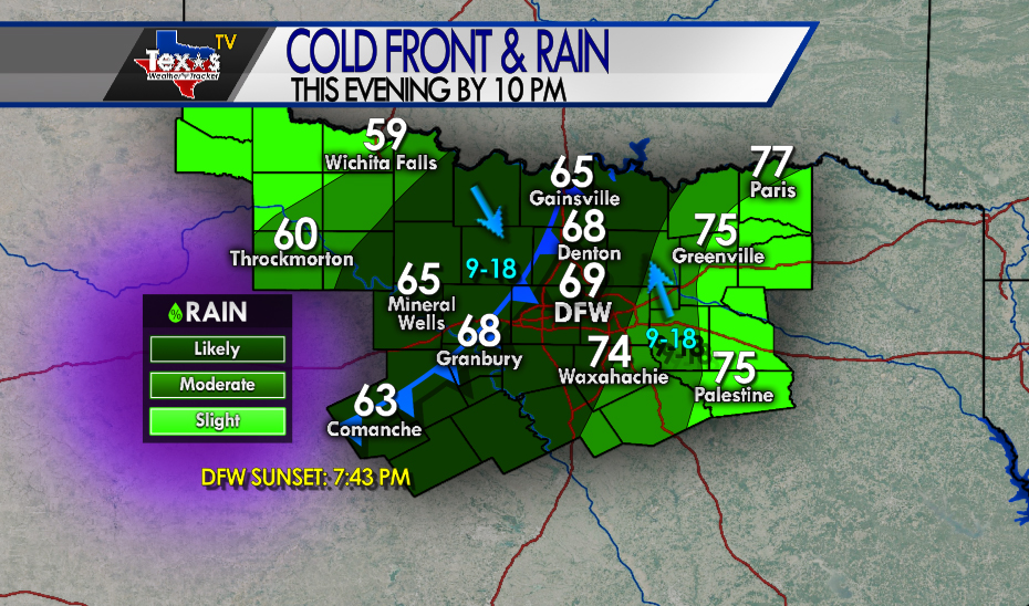
A cold front will continue to slowly push into the Metroplex this evening. Rain and T-Storm chances will be best near the I-35 corridor. Locally heavy rain and ponding on the roadway is likely. Severe weather is not expected.