
Here’s a look at Live Temperatures across North Texas, MesoScan Radar and the Updated Forecast Map.
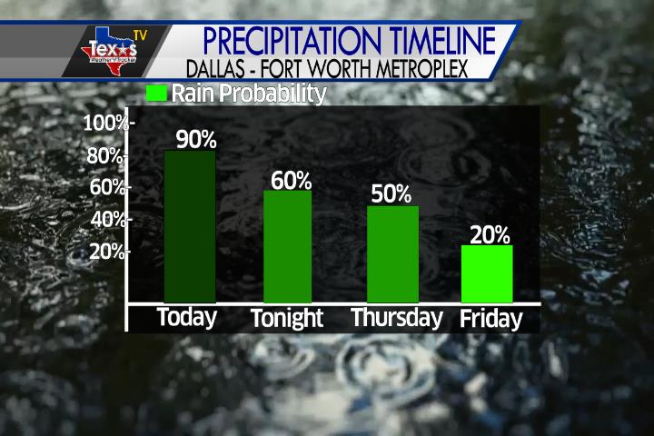
DFW thru 5 pm this afternoon… Showers and T-Storms. Highs in the lower 80s. East winds around 5 mph. Chance of rain 90 percent. -William


Here’s a look at Live Temperatures across North Texas, MesoScan Radar and the Updated Forecast Map.
DFW thru 5 pm this afternoon… Showers and T-Storms. Highs in the lower 80s. East winds around 5 mph. Chance of rain 90 percent. -William

From the National Hurricane Center:
Corrected Friday to Thursday in the second paragraph For the North Atlantic Caribbean Sea and the Gulf of Mexico: The National Hurricane Center is issuing advisories on Tropical Storm Paulette, located over the central tropical Atlantic, and on Tropical Depression Rene, located over the eastern tropical Atlantic. A small area of low pressure located about 375 miles southeast of Wilmington, North Carolina, continues to produce minimal shower and thunderstorm activity near its center of circulation. The low is forecast to move northwestward at 10 to 15 mph, and some development is possible before it moves inland over eastern North Carolina Thursday afternoon. Interests along the coasts of North and South Carolina should continue to monitor the progress of this disturbance. * Formation chance through 48 hours low 30 percent. * Formation chance through 5 days low 30 percent. A tropical wave is forecast to emerge off the west coast of Africa on Thursday. Gradual development is expected once the system moves over water, and a tropical depression is likely to form late this week or over the weekend while the system moves generally westward across the eastern tropical Atlantic. * Formation chance through 48 hours medium 40 percent. * Formation chance through 5 days high 80 percent. Forecaster Berg
Rain chances will quickly be increasing as we go through the day in Metroplex. Keep the umbrella handy. Also, plan on a wet evening commute.
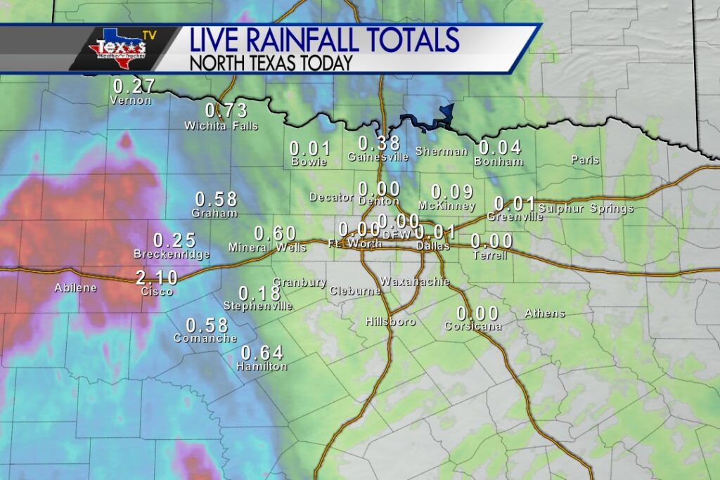
Rainfall totals in our Western Counties since midnight continue to add up. An area of moderate to heavy rain will continue to shift east through the day. .25″ – .75″ are fairly common amounts – so far at mid morning.

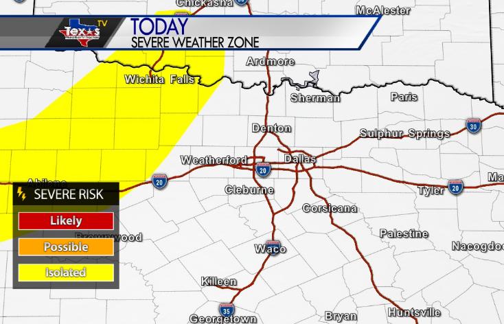
William’s North Texas Hazardous Weather Forecast for Wednesday:
Widespread showers and T-Storms are expected across much of North and Central Texas. The most widespread and heaviest rainfall is expected to remain along and west of I-35 thru 5 pm this afternoon… and evening. Flooding will be the primary concern across this area. Severe weather is not expected.

DFW Today Cloudy. A chance of showers and T-Storms this morning then showers and T-Storms likely thru 5 pm this afternoon…. Highs in the mid 80s. Southeast winds around 5 mph. Chance of rain 70 percent. -William
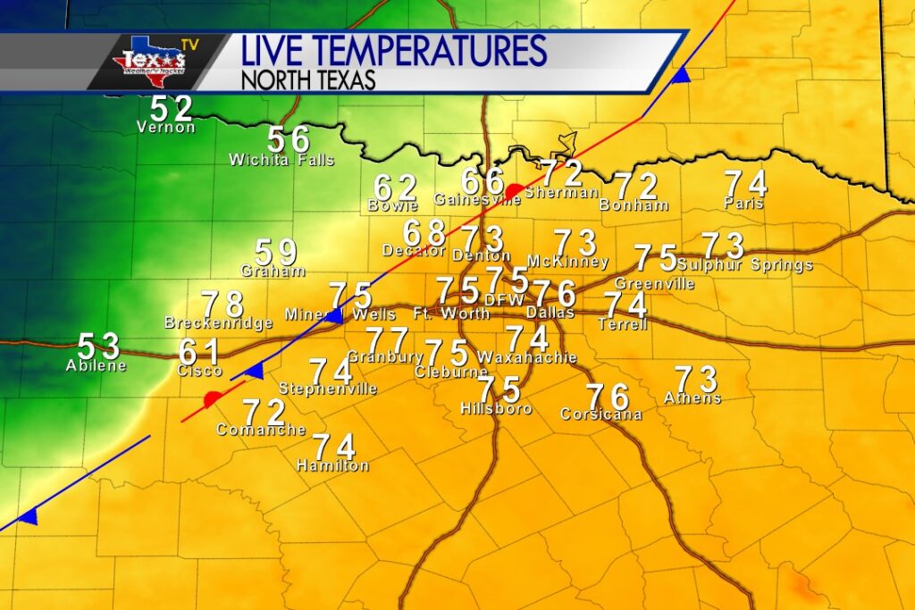
A slow moving cold front continues to slide into North Texas this morning. Temperatures are substantially cooler behind the front. Scattered showers and T-Storms are also ongoing near the front. Locally heavy rain is possible. This front will move into and through the Metroplex as we go through the day.
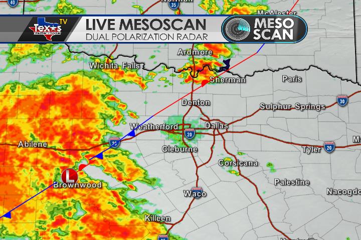
Here’s a look at MesoScan Radar and Live Temperatures across North Texas.
DFW thru sunrise… Cloudy. A slight chance of showers and perhaps an isolated thunderstorm late this evening then a chance of showers and T-Storms. Temperatures steady in the mid 70s. Southeast winds around 5 mph. Chance of rain 30 percent.

From William Cole: A Flash Flood Warning has been issued for Baylor County in North TX until 11:30 PM.
At 840 PM CDT, MesoScan Radar indicated T-Storms producing heavy rain across the warned area. Between 2 and 4 inches of rain have fallen. Flash flooding is ongoing or expected to begin shortly.
Remember if you see water across a roadway do not drive through it. Turn Around Don’t Drown.
Stay with William Cole and Texas Weather Tracker TV for continuing coverage, online, on our app and on TV. Let’s stay safe together.

If you have not already downloaded the Free Texas Weather Tracker TV mobile app – do that now. Search your app store for Texas Weather Tracker TV. Also, add our free Live Channel to your TV through Roku, Apple or Amazon Fire TV streaming players.

Like our forecasts? Love our severe weather coverage? Help support us and local Texas weather coverage. Join our Patreon for $2.99 per month. www.patreon.com/texasweathertrackertv

As a line of storms continues this evening in our Northwestern Counties near a cold front moving into the area. Strong to a marginally severe storm can’t be ruled out. Heavy rain, vivid lightning and winds to 50 mph – possibly 60 mph would be the primary concerns.