NOW Update 6:18 PM : Wichita & Wilbarger Counties

Texas Weather Tracker TV Alert

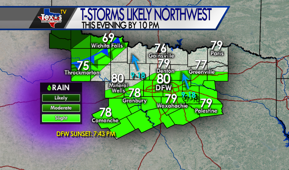
From William Cole: AT 616 PM CDT, strong T-Storms were along a line extending from near Fargo to 3 miles northeast of Harrold to 5 miles north of Lake Diversion, moving northeast at 30 MPH. You can expect Wind gusts to 50 MPH Minor flooding in areas of poor drainage Locations impacted include Vernon, Frederick, Electra, Grandfield, Davidson, Hollister, Loveland, Fargo, Oklaunion, Harrold, Grayback and Haynesville. PRECAUTIONARY/PREPAREDNESS ACTIONS Monitor the weather situation closely and be alert for threatening weather conditions.

Stay with William Cole and Texas Weather Tracker TV for continuing coverage, online, on our app and on TV.

If you have not already downloaded the Free Texas Weather Tracker TV mobile app – do that now. Search your app store for Texas Weather Tracker TV. Also, add our free Live Channel to your TV through Roku, Apple or Amazon Fire TV.

Severe Weather Update 5:50 PM : Baylor & Wilbarger Counties

Texas Weather Tracker TV Alert

From William Cole: A T-Storm Warning continues for for Baylor & Wilbarger Counties in North TX until 6:15 PM.

At 550 PM CDT, severe T-Storms were located along a line extending from 5 miles southwest of Grayback to 7 miles northeast of Lake Kemp to 4 miles north of Seymour, moving east at 30 mph.

Primary Threats: 60 Mph Wind Gusts.

Stay with William Cole and Texas Weather Tracker TV for continuing coverage, online, on our app and on TV. Let’s stay safe together.

Download App

If you have not already downloaded the Free Texas Weather Tracker TV mobile app – do that now. Search your app store for Texas Weather Tracker TV. Also, add our free Live Channel to your TV through Roku, Apple or Amazon Fire TV streaming players.

Streaming Servicet

Like our forecasts? Love our severe weather coverage? Help support us and local Texas weather coverage. Join our Patreon for $2.99 per month. www.patreon.com/texasweathertrackertv

Patreon

ALERT 5:30 PM | T-Storm Warning Baylor & Wilbarger Counties until 6:15 PM

Texas Weather Tracker TV Alert

From William Cole: A T-Storm Warning has been issued for Baylor & Wilbarger Counties in North TX until 6:15 PM.

At 530 PM CDT, severe T-Storms were located along a line extending from 12 miles southwest of Grayback to 3 miles west of Lake Kemp to 3 miles northwest of Seymour, moving northeast at 25 mph.

Hometowns Impacted: Lake Kemp, Harrold, Grayback And Lake Diversion.

Primary Threats: 60 Mph Wind Gusts.

Stay with William Cole and Texas Weather Tracker TV for continuing coverage, online, on our app and on TV. Let’s stay safe together.

Download App

If you have not already downloaded the Free Texas Weather Tracker TV mobile app – do that now. Search your app store for Texas Weather Tracker TV. Also, add our free Live Channel to your TV through Roku, Apple or Amazon Fire TV streaming players.

Streaming Servicet

Like our forecasts? Love our severe weather coverage? Help support us and local Texas weather coverage. Join our Patreon for $2.99 per month. www.patreon.com/texasweathertrackertv

Patreon

NOW Update 5:19 PM : Baylor & Wilbarger Counties

Texas Weather Tracker TV Alert

From William Cole: AT 516 PM CDT, strong T-Storms were along a line extending from 6 miles southeast of Chillicothe to 10 miles northwest of Lake Kemp to 4 miles northeast of Bomarton, moving northeast at 15 MPH. You can expect Wind gusts to 50 MPH Minor flooding in areas of poor drainage Locations impacted include Vernon, Seymour, Red Springs, Lockett, Lake Kemp and Bomarton. PRECAUTIONARY/PREPAREDNESS ACTIONS Monitor the weather situation closely and be alert for threatening weather conditions.

Stay with William Cole and Texas Weather Tracker TV for continuing coverage, online, on our app and on TV.

If you have not already downloaded the Free Texas Weather Tracker TV mobile app – do that now. Search your app store for Texas Weather Tracker TV. Also, add our free Live Channel to your TV through Roku, Apple or Amazon Fire TV.

Atlantic Tropical Weather Outlook

Texas Weather Tracker TV Alert

From the National Hurricane Center:

For the North Atlantic Caribbean Sea and the Gulf of Mexico: The National Hurricane Center is issuing advisories on Tropical Storm Paulette, located over the central tropical Atlantic, and on Tropical Storm Rene, located near the western Cabo Verde Islands. An area of low pressure is located about 300 miles west-southwest of Bermuda. Showers and thunderstorm activity associated with the low has increased since last night, but remains somewhat disorganized. Gradual additional development of this system is possible during the next two or three days and it could become a tropical depression while it moves slowly westward to west-northwestward. Interests along the southeast coast of the U.S. should monitor the progress of this disturbance. * Formation chance through 48 hours low 30 percent. * Formation chance through 5 days medium 40 percent. A tropical wave is forecast to emerge off the west coast of Africa by Thursday. Gradual development is expected once the system moves over water, and a tropical depression is likely to form late this week or over the weekend while the system moves generally westward across the eastern tropical Atlantic. * Formation chance through 48 hours low near 0 percent. * Formation chance through 5 days high 70 percent. Forecaster Zelinsky