
DFW -William
DFW -William

BETA STARTING TO MOVE EAST AND CONTINUES TO BE A HEAVY RAINFALL AND FLOODING THREAT OVER PORTIONS OF THE UPPER TEXAS COAST INTO THE LOWER MISSISSIPPI RIVER VALLEY
At 1000 PM CDT (0300 UTC), the center of Post-Tropical Cyclone Beta was located near latitude 29.1 North, longitude 95.4 West. The post-tropical cyclone is moving toward the northeast near 8 mph (13 km/h) and this motion is expected to continue through the next 48 hours.

If you have not already downloaded the Free Texas Weather Tracker TV mobile app – do that now. Search your app store for Texas Weather Tracker TV. Also, add our free Live Channel to your TV through Roku, Apple or Amazon Fire TV streaming players.

Like our forecasts? Love our severe weather coverage? Help support us and local Texas weather coverage. Join our Patreon for $2.99 per month. www.patreon.com/texasweathertrackertv


William’s North Texas Hazardous Weather Forecast this Evening:
Brief moderate rainfall may result in minor flooding across parts of East Texas thru 5 pm this afternoon…. Otherwise, severe weather is not expected.
DFW Tonight Mostly cloudy with a 20 percent chance of rain. Lows in the mid 60s. Northeast winds around 5 mph. -William

SLOW-MOVING BETA PRODUCING HEAVY RAINFALL AND FLOODING OVER PORTIONS OF THE UPPER TEXAS COAST… …THIS IS THE LAST ADVISORY ISSUED BY THE NATIONAL HURRICANE CENTER
At 400 PM CDT (2100 UTC), the center of Tropical Depression Beta was located by surface observations, satellites, and NOAA Doppler weather radars near latitude 29.0 North, longitude 96.3 West. The depression is moving toward the east-northeast near 5 mph (7 km/h) and this general motion is expected to continue through Friday. On the forecast track, the center of Beta will move inland over southeastern Texas through Wednesday and then over Louisiana and Mississippi Wednesday night through Friday.
If you have not already downloaded the Free Texas Weather Tracker TV mobile app – do that now. Search your app store for Texas Weather Tracker TV. Also, add our free Live Channel to your TV through Roku, Apple or Amazon Fire TV streaming players.
Like our forecasts? Love our severe weather coverage? Help support us and local Texas weather coverage. Join our Patreon for $2.99 per month. www.patreon.com/texasweathertrackertv
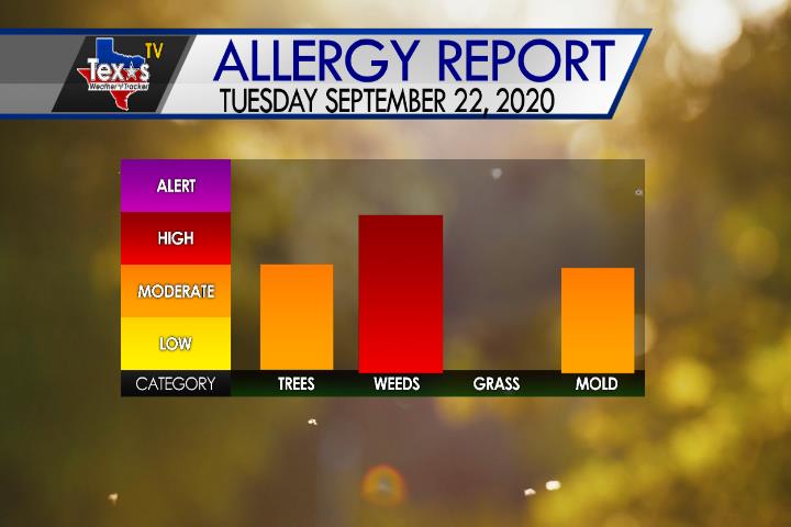
The Ragweed Pollen remains high today with the Elm Tree Pollen and Mold Spores elevated.
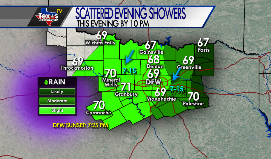
Scattered showers remain possible this evening – mainly in our Eastern Counites. Cloudy skies continue with even a few areas of fine drizzle.

Here’s a look at Live Temperatures across North Texas, MesoScan Radar and the Updated Forecast Map.
DFW Today Cloudy. Widespread drizzle and showers likely this morning then a chance of showers thru 5 pm this afternoon…. Highs in the lower 70s. Northeast winds around 5 mph. Chance of rain 60 percent. -William


Here’s a look at Live Temperatures across North Texas, MesoScan Radar and the Updated Forecast Map.
DFW thru 5 pm this afternoon… Cloudy with a 30 percent chance of rain. Temperatures steady in the lower 70s. Northeast winds 5 to 10 mph. -William

From the National Hurricane Center:
For the North Atlantic Caribbean Sea and the Gulf of Mexico: The National Hurricane Center is issuing advisories on Tropical Storm Beta, located over the Texas coast, on Hurricane Teddy, located several hundred miles south of Halifax, Nova Scotia, and on Tropical Storm Paulette, located a few hundred miles southeast of the Azores. Showers and T-Storms extending from the southeastern Bahamas westward through Cuba and into the southeastern Gulf of Mexico are associated with a cold front. This system is forecast to move slowly southward during the next couple of days, and then move back northward on Thursday through Saturday. Development, if any, over the southeastern Gulf of Mexico late this week is expected to be slow to occur. Regardless of development, locally heavy rainfall is possible over portions of Cuba on Tuesday and Wednesday and over the Florida Keys and south Florida on Thursday and Friday. * Formation chance through 48 hours low near 0 percent. * Formation chance through 5 days low 10 percent. Public Advisories on Paulette are issued under WMO header WTNT31 KNHC and under AWIPS header MIATCPAT1. Forecast/Advisories on Paulette are issued under WMO header WTNT21 KNHC and under AWIPS header MIATCMAT1. Forecaster Blake