Atlantic Tropical Weather Outlook

Texas Weather Tracker TV Alert

From the National Hurricane Center:

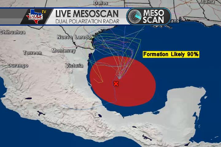
For the North Atlantic Caribbean Sea and the Gulf of Mexico: The National Hurricane Center is issuing advisories on Hurricane Teddy, located over the central tropical Atlantic, and on Tropical Depression Twenty-Two, located over the southwestern Gulf of Mexico. Showers and T-Storms associated with an area of low pressure located a few hundred miles southwest of the Cabo Verde Islands are becoming better organized. Earlier satellite-derived wind data indicated that this system does not yet have a well-defined center, but it is producing winds near tropical-storm-force to its east. Environmental conditions are expected to be conducive for additional development during the next day or two and a tropical depression or tropical storm is likely to form before the end of the week. This system is forecast move west-northwestward at 10 to 15 mph through the weekend. For more information on this system, please see High Seas Forecasts issued by Texas Weather Tracker TV, * Formation chance through 48 hours high 70 percent. * Formation chance through 5 days high 70 percent. A small low pressure system located just west of the coast of Portugal is embedded within a larger non-tropical low. Although showers and T-Storms associated with the smaller low are showing signs of organization, the system will soon move inland over Portugal and further tropical or subtropical development is unlikely. The low is producing gale-force winds, and will likely bring gusty winds and brief periods of heavy rain to portions of western Portugal Today and Tonight. For more information about potential hazards in Portugal, please see products issued by the Portuguese Institute for the Sea and the Atmosphere (IPMA). For more information about marine hazards associated with this system, see High Seas Forecasts issued by Meteo France. * Formation chance through 48 hours low 20 percent. * Formation chance through 5 days low 20 percent. Post-tropical cyclone Paulette is located several hundred miles north-northwest of the Azores. The cyclone is forecast to move quickly southward for the next few days and then stall over marginally warm waters a few hundred miles south or south-southwest of the Azores by the end of the weekend. The cyclone could subsequently redevelop tropical characteristics late this weekend or early next week while it moves little. * Formation chance through 48 hours low 20 percent. * Formation chance through 5 days low 30 percent. Another tropical wave is forecast to move off the west coast of Africa by early Saturday. Some gradual development of the system will be possible thereafter while it moves generally west-northwestward over the far eastern Atlantic. * Formation chance through 48 hours low near 0 percent. * Formation chance through 5 days low 20 percent. Public Advisories on Tropical Depression Twenty-Two are issued under WMO header WTNT32 KNHC and under AWIPS header MIATCPAT2. Forecast/Advisories on Tropical Depression Twenty-Two are issued under WMO header WTNT22 KNHC and under AWIPS header MIATCMAT2. Products issued by the Portuguese Institute for the Sea and the Atmosphere (IPMA) are available on the web at www.ipma.pt. High Seas Forecasts issued by Meteo France can be found under WMO header FQNT50 LFPW and available on the web at www.meteofrance.com/previsions-meteo-marine/bulletin/grandlarge/ metarea2 High Seas Forecasts issued by Texas Weather Tracker TV can be found under AWIPS header NFDHSFAT1, WMO header FZNT01 KWBC, and online at ocean.weather.gov/shtml/NFDHSFAT1.php Forecaster Latto

SLOW-MOVING DEPRESSION CLOSE TO TROPICAL STORM STRENGTH

Texas Weather Tracker TV Alert

SLOW-MOVING DEPRESSION CLOSE TO TROPICAL STORM STRENGTH

At 1000 AM CDT (1500 UTC), the center of Tropical Depression Twenty-Two was located near latitude 23.8 North, longitude 93.9 West. The depression is moving toward the north-northeast near 7 mph (11 km/h), and this general motion is expected through early Saturday. A slow westward motion is forecast to begin late Saturday or Saturday night, and this motion will likely continue into early next week.

Download App

If you have not already downloaded the Free Texas Weather Tracker TV mobile app – do that now. Search your app store for Texas Weather Tracker TV. Also, add our free Live Channel to your TV through Roku, Apple or Amazon Fire TV streaming players.

Streaming Servicet

Like our forecasts? Love our severe weather coverage? Help support us and local Texas weather coverage. Join our Patreon for $2.99 per month. www.patreon.com/texasweathertrackertv

Patreon

SLOW MOVING DEPRESSION FORECAST TO BECOME A TROPICAL STORM LATER TODAY

Texas Weather Tracker TV Alert

SLOW MOVING DEPRESSION FORECAST TO BECOME A TROPICAL STORM LATER TODAY

At 400 AM CDT (0900 UTC), the center of Tropical Depression Twenty-Two was located near latitude 22.9 North, longitude 94.1 West. The depression is moving toward the north-northeast near 6 mph (9 km/h), and this general motion is expected through early Saturday. A slow westward motion is forecast to begin late Saturday that will likely continue into early next week.

Download App

If you have not already downloaded the Free Texas Weather Tracker TV mobile app – do that now. Search your app store for Texas Weather Tracker TV. Also, add our free Live Channel to your TV through Roku, Apple or Amazon Fire TV streaming players.

Streaming Servicet

Like our forecasts? Love our severe weather coverage? Help support us and local Texas weather coverage. Join our Patreon for $2.99 per month. www.patreon.com/texasweathertrackertv

Patreon

DEPRESSION EXPECTED TO STRENGTHEN WHILE IT MOVES SLOWLY NORTHWARD OVER THE WESTERN GULF OF MEXICO

Texas Weather Tracker TV Alert

DEPRESSION EXPECTED TO STRENGTHEN WHILE IT MOVES SLOWLY NORTHWARD OVER THE WESTERN GULF OF MEXICO

At 1000 PM CDT (0300 UTC), the center of Tropical Depression Twenty-Two was located near latitude 22.0 North, longitude 94.2 West. The depression is moving toward the northeast near 3 mph (6 km/h). A slow north-northeastward motion is expected through early Saturday, with a slow turn toward the north and then west anticipated over the weekend.

Download App

If you have not already downloaded the Free Texas Weather Tracker TV mobile app – do that now. Search your app store for Texas Weather Tracker TV. Also, add our free Live Channel to your TV through Roku, Apple or Amazon Fire TV streaming players.

Streaming Servicet

Like our forecasts? Love our severe weather coverage? Help support us and local Texas weather coverage. Join our Patreon for $2.99 per month. www.patreon.com/texasweathertrackertv

Patreon

TROPICAL DEPRESSION FORMS OVER THE SOUTHWESTERN GULF OF MEXICO… …EXPECTED TO MOVE SLOWLY OVER THE WESTERN GULF INTO EARLY NEXT WEEK

Texas Weather Tracker TV Alert

TROPICAL DEPRESSION FORMS OVER THE SOUTHWESTERN GULF OF MEXICO… …EXPECTED TO MOVE SLOWLY OVER THE WESTERN GULF INTO EARLY NEXT WEEK

At 600 PM CDT (2300 UTC), the center of Tropical Depression Twenty-Two was located near latitude 21.9 North, longitude 94.3 West. The depression is moving toward the northeast near 5 mph (7 km/h), and it is expected to generally meander over the western Gulf of Mexico into the weekend.

Download App

If you have not already downloaded the Free Texas Weather Tracker TV mobile app – do that now. Search your app store for Texas Weather Tracker TV. Also, add our free Live Channel to your TV through Roku, Apple or Amazon Fire TV streaming players.

Streaming Servicet

Like our forecasts? Love our severe weather coverage? Help support us and local Texas weather coverage. Join our Patreon for $2.99 per month. www.patreon.com/texasweathertrackertv

Patreon

Gulf Tropical Formation

It’s likely we will see our next tropical system form in the Gulf of Mexico over the next 24 – 48 hours. The National Hurricane Center is giving this disturbance a 90% chance of development into a tropical depression, storm or more. Where is the track for this system? There is still a huge question mark on that – the steering currents are weak in the Gulf. It appears it will just meander around for a few days before potentially heading North. This map shows the “spaghetti plots” which is all of the different computer models and the path they are indicating. You can see that they are currently all over the place.