DFW Tonight Mostly cloudy. A slight chance of showers and T-Storms this evening then a chance of showers and T-Storms after midnight. Lows in the lower 70s. Southeast winds around 5 mph. Chance of rain 30 percent. -William

DFW Tonight Mostly cloudy. A slight chance of showers and T-Storms this evening then a chance of showers and T-Storms after midnight. Lows in the lower 70s. Southeast winds around 5 mph. Chance of rain 30 percent. -William
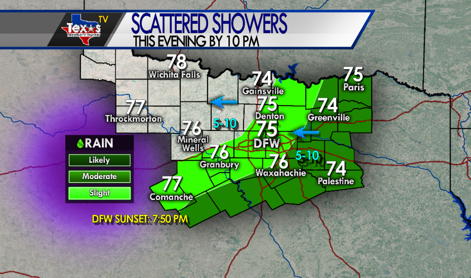
Scattered showers and rain remain possible this evening mainly South and East of the Metroplex. A few pockets of heavy rain are also possible. Temperatures hold steady in the 70’s.

Here’s a look at Live Temperatures across North Texas, MesoScan Radar and the Updated Forecast Map.
DFW thru 5 pm this afternoon… Cloudy with a 40 percent chance of showers and T-Storms. Highs in the mid 80s. Southeast winds around 5 mph. -William


Here are Thursday’s Live Lake Levels across North Texas.

From the National Hurricane Center:
For the North Atlantic Caribbean Sea and the Gulf of Mexico: The National Hurricane Center is issuing advisories on Tropical Storm Nana, inland over southern Belize, and on Tropical Depression Omar, located a few hundred miles north-northeast of Bermuda. A broad area of low pressure located over the eastern tropical Atlantic several hundred miles west-southwest of the Cabo Verde Islands is producing a small area of disorganized showers and T-Storms. Gradual development is possible early next week as the larger tropical wave located off of the coast of Africa passes to the north of the system on Sunday. * Formation chance through 48 hours low 20 percent. * Formation chance through 5 days medium 40 percent. A tropical wave located off the coast of west Africa is merging with another disturbance located a couple of hundred miles south of the Cabo Verde Islands, resulting in an extensive area of disorganized showers and T-Storms. Development of this system is likely to be slow during the next couple of days while it moves west- northwestward at about 15 mph, and a tropical depression is more likely to form early next week over the central tropical Atlantic where environmental conditions are forecast to be more favorable for development. * Formation chance through 48 hours low 20 percent. * Formation chance through 5 days high 70 percent. Another tropical wave is forecast to move off the west coast of Africa over the weekend. An area of low pressure is expected to form from the wave, and some development of this low will be possible early next week while it moves generally westward over the far eastern tropical Atlantic. * Formation chance through 48 hours low near 0 percent. * Formation chance through 5 days low 20 percent. Forecaster Roberts

William’s North Texas Hazardous Weather Forecast for Thursday:
Scattered to numerous showers and storms, some containing brief heavy downpours, are possible southeast of a Sulphur Springs to Dallas to Comanche line this morning. Look for activity to be more isolated or widely scattered in nature further northwest Today. Low chances are expected to continue across Central Texas Tonight. In addition to heavy rainfall, other threats will include lightning strikes and possibly small hail.

DFW Today Partly sunny this morning then becoming mostly sunny. A 30 percent chance of showers and T-Storms. Highs in the upper 80s. South winds around 5 mph. -William
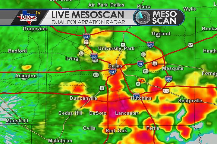
Areas of heavy are on going in Dallas County. Ponding on the roadways and traffic slowdowns are likely.
Here’s a look at MesoScan Radar and Live Temperatures across North Texas.
DFW thru sunrise… Mostly cloudy. A chance of showers and T-Storms early then showers and T-Storms likely. Heavy rainfall possible. Lows in the lower 70s. Southeast winds around 5 mph. Chance of rain 60 percent.
William’s North Texas Hazardous Weather Forecast this Evening:
Scattered to numerous T-Storms are possible through Tonight. Severe storms are not expected, however, some storms may produce heavy rainfall which may result in instances of flash flooding.