Atlantic Tropical Weather Outlook

Texas Weather Tracker TV Alert

From the National Hurricane Center:

For the North Atlantic Caribbean Sea and the Gulf of Mexico: The National Hurricane Center is issuing advisories on Tropical Storm Omar, located a few hundred miles northwest of Bermuda, and on Tropical Storm Nana, located a couple hundred miles northeast of the coast of Honduras. Showers and T-Storms associated with an area of low pressure located about midway between the Windward Islands and west Africa remain disorganized. Some development of this system, however, is possible this week as it meanders over the eastern and central tropical Atlantic Ocean. * Formation chance through 48 hours low 20 percent. * Formation chance through 5 days low 30 percent. Surface observations and satellite derived data indicate that a tropical wave has emerged off the coast of Africa. The wave is expected to merge with a disturbance centered a couple of hundred miles southeast of the Cabo Verde Islands in the next day or so. Gradual development of this system is then possible, and a tropical depression could form by this weekend while it moves westward over the eastern and central tropical Atlantic Ocean. * Formation chance through 48 hours low 10 percent. * Formation chance through 5 days medium 60 percent. Public Advisories on Tropical Storm Nana are issued under WMO header WTNT31 KNHC and under AWIPS header MIATCPAT1. Forecast/Advisories on Tropical Storm Nana are issued under WMO header WTNT21 KNHC and under AWIPS header MIATCMAT1. Forecaster Roberts

NOW Update Tuesday 11:50 PM: Henderson & Navarro Counties

Texas Weather Tracker TV Alert

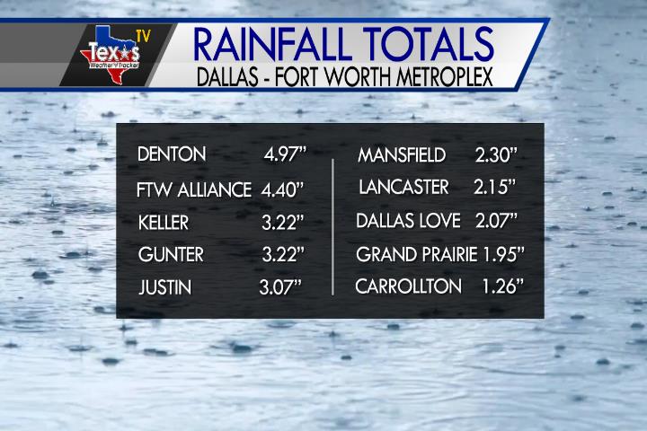
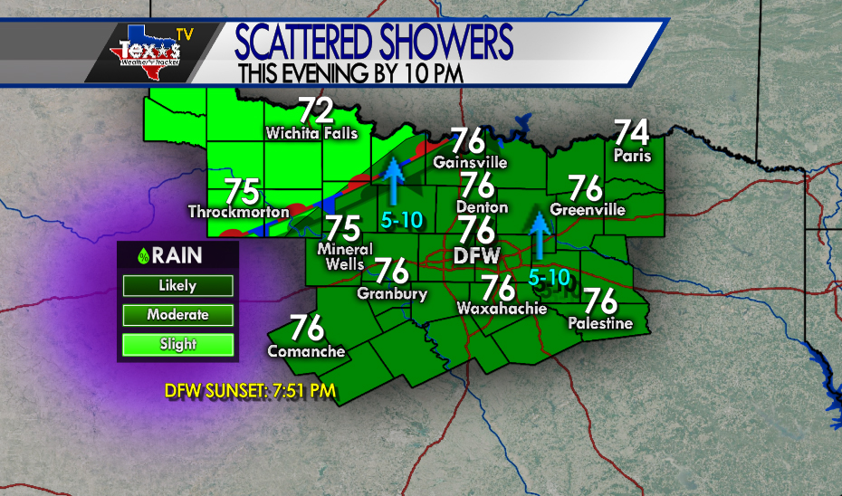
From William Cole: At 1150 PM CDT, MesoScan Radar was tracking a strong thunderstorm 7 miles south of Kerens, or 16 miles east of Corsicana, moving northeast at 55 mph. Winds in excess of 40 mph will be possible with this storm. Locations impacted include Athens, Malakoff, Kerens, Eustace, Trinidad, Caney City, Log Cabin, Murchison, Star Harbor, Mildred, Eureka and Goodlow. LAT LON 3202 9592 3201 9606 3192 9624 3207 9636 3236 9591 3236 9576 3215 9559 TIME MOT LOC 0450Z 232DEG 49KT 3202 9618

Stay with William Cole and Texas Weather Tracker TV for continuing coverage, online, on our app and on TV. Let’s stay safe together.

Download App

If you have not already downloaded the Free Texas Weather Tracker TV mobile app – do that now. Search your app store for Texas Weather Tracker TV. Also, add our free Live Channel to your TV through Roku, Apple or Amazon Fire TV streaming players.

Streaming Servicet

Like our forecasts? Love our severe weather coverage? Help support us and local Texas weather coverage. Join our Patreon for $2.99 per month. www.patreon.com/texasweathertrackertv

Patreon

NOW Update Tuesday 9:03 PM: Comanche, Erath & Hamilton Counties

Texas Weather Tracker TV Alert

From William Cole: At 903 PM CDT, MesoScan Radar was tracking a strong thunderstorm 8 miles southwest of Gustine, or 10 miles southeast of Comanche, moving east at 40 mph. Wind gusts up to 50 mph will be possible with this storm. Locations impacted include Comanche, Hamilton, Hico and Gustine. Torrential rainfall is also occurring with this storm, and may lead to localized flooding. Do not drive your vehicle through flooded roadways. Frequent cloud to ground lightning is occurring with this storm. Seek a safe shelter inside a building or vehicle.

Stay with William Cole and Texas Weather Tracker TV for continuing coverage, online, on our app and on TV. Let’s stay safe together.

Download App

If you have not already downloaded the Free Texas Weather Tracker TV mobile app – do that now. Search your app store for Texas Weather Tracker TV. Also, add our free Live Channel to your TV through Roku, Apple or Amazon Fire TV streaming players.

Streaming Servicet

Like our forecasts? Love our severe weather coverage? Help support us and local Texas weather coverage. Join our Patreon for $2.99 per month. www.patreon.com/texasweathertrackertv

Patreon