Good Sunday morning. Scattered showers are ongoing this morning across North Texas. Currently nothing heavy – just light to moderate rain. The roadways are wet so if you’re stepping out to morning services be sure to give yourself extra time.
Good Sunday morning. Scattered showers are ongoing this morning across North Texas. Currently nothing heavy – just light to moderate rain. The roadways are wet so if you’re stepping out to morning services be sure to give yourself extra time.

DFW TODAY…Mostly cloudy. A 50 percent chance of showers this morning. Highs around 80. Southeast winds 5 to 10 mph. -William

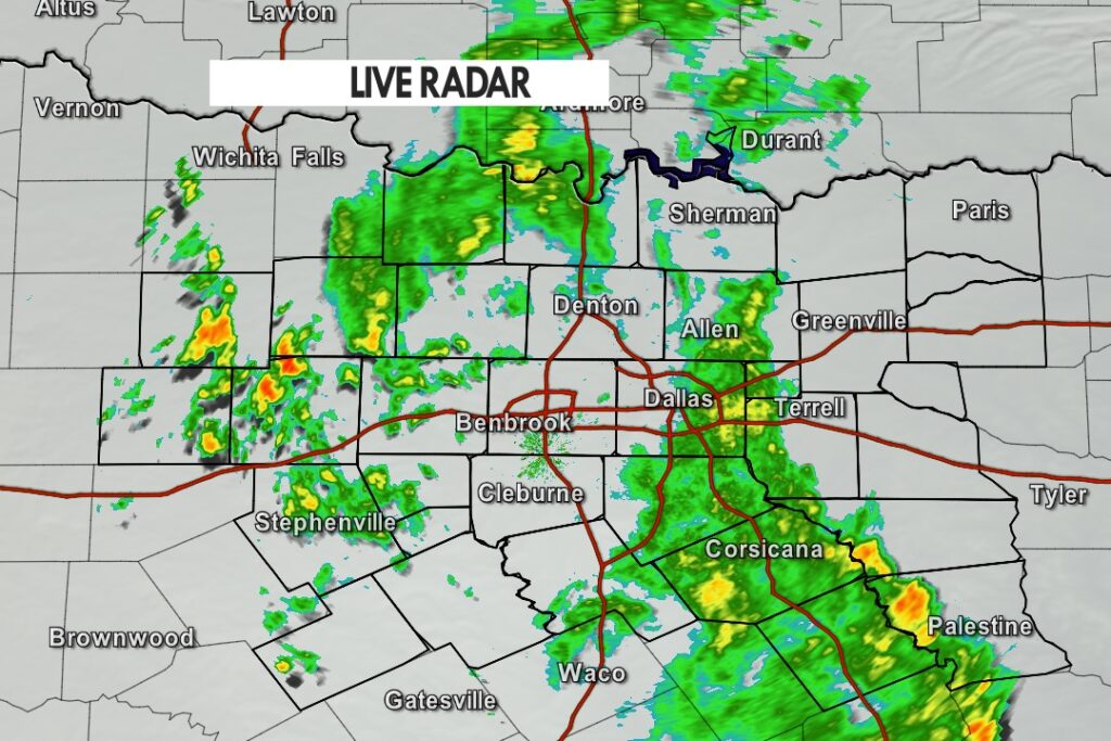
Here’s a look at MesoScan Radar and Live Temperatures across North Texas.
DFW REST OF TONIGHT…Cloudy with a 50 percent chance of showers. Lows in the upper 60s. Southeast winds 5 to 10 mph.


William’s North Texas Hazardous Weather Forecast this Evening:
Scattered storms will be possible this evening before becoming more isolated overnight. Lightning will be the primary hazard, although a few storms will be capable of producing a tropical funnel and gusty winds through mid-evening.

From William Cole: At 610 PM CDT, Doppler radar was tracking a strong shower over Ennis, moving north at 10 mph. Winds in excess of 30 mph will be possible with this storm along with brief funnel clouds. Locations impacted include… Ennis, Ferris, Palmer, Garrett and Pecan Hill. LAT…LON 3229 9665 3249 9679 3255 9661 3254 9660 3231 9657 TIME…MOT…LOC 2310Z 157DEG 10KT 3235 9664
Stay with William Cole and Texas Weather Tracker TV for continuing coverage, online, on our app and on TV. Let’s stay safe together.

If you have not already downloaded the Free Texas Weather Tracker TV mobile app – do that now. Search your app store for Texas Weather Tracker TV. Also, add our free Live Channel to your TV through Roku, Apple or Amazon Fire TV streaming players.

Like our forecasts? Love our severe weather coverage? Help support us and local Texas weather coverage. Join our Patreon for $2.99 per month. www.patreon.com/texasweathertrackertv

From William Cole: At 518 PM CDT, Doppler radar was tracking a heavy shower near Midlothian, moving north at 15 mph. Gusty winds up to 30 mph and brief funnel clouds will be possible with this shower. Locations impacted include… Grand Prairie, Mansfield, Desoto, Cedar Hill, Duncanville, Waxahachie, Midlothian, Glenn Heights, Red Oak, Ovilla and Oak Leaf.
Stay with William Cole and Texas Weather Tracker TV for continuing coverage, online, on our app and on TV. Let’s stay safe together.
If you have not already downloaded the Free Texas Weather Tracker TV mobile app – do that now. Search your app store for Texas Weather Tracker TV. Also, add our free Live Channel to your TV through Roku, Apple or Amazon Fire TV streaming players.
Like our forecasts? Love our severe weather coverage? Help support us and local Texas weather coverage. Join our Patreon for $2.99 per month. www.patreon.com/texasweathertrackertv
DFW TONIGHT…Cloudy with a chance of showers and perhaps an isolated thunderstorm. Lows in the upper 60s. Southeast winds 10 to 15 mph, diminishing to 5 to 10 mph after midnight. Chance of rain 50 percent. -William

Here’s a look at Live Temperatures across North Texas, MesoScan Radar and the Updated Forecast Map.
DFW TODAY…Cloudy. A slight chance of showers this morning, then showers likely with isolated thunderstorms this afternoon. Highs in the upper 70s. Southeast winds around 10 mph. Chance of rain 60 percent. -William


Here are Saturday’s Live Lake Levels across North Texas.

From the National Hurricane Center:
For the North Atlantic…Caribbean Sea and the Gulf of Mexico:
The National Hurricane Center is issuing advisories on recently developed Subtropical Storm Ana, located about 180 miles northeast of Bermuda.
Surface observations and radar data indicate that the area of low pressure previously over the northwestern Gulf of Mexico has moved inland over southeastern Texas. Therefore, tropical cyclone formation is not expected. However, the system could produce heavy rainfall over portions of southeastern Texas and southwestern Louisiana today. Given the complete saturation of soils with ongoing river flooding along the Texas and Louisiana coastal areas, these rains could lead to flash, urban, and additional riverine flooding across this region. Additional information on the rainfall and flooding potential can be found in products issued by your local National Weather Service Forecast Office. * Formation chance through 48 hours…low…near 0 percent. * Formation chance through 5 days…low…near 0 percent.
&& Public Advisories on Subtropical Storm Ana are issued under WMO header WTNT31 KNHC and under AWIPS header MIATCPAT1. Forecast/Advisories on Subtropical Storm Ana are issued under WMO header WTNT21 KNHC and under AWIPS header MIATCMAT1.
$$ Forecaster Beven