
William’s North Texas Hazardous Weather Forecast for Saturday:
Scattered storms will be possible today. Lightning will be the primary hazard. Brief heavy rainfall may lead to flooding of low- lying areas.
William’s North Texas Hazardous Weather Forecast for Saturday:
Scattered storms will be possible today. Lightning will be the primary hazard. Brief heavy rainfall may lead to flooding of low- lying areas.

DFW TODAY…Cloudy. A slight chance of showers this morning, then showers likely with isolated thunderstorms this afternoon. Highs in the upper 70s. Southeast winds around 10 mph. Chance of rain 60 percent. -William

Here’s a look at MesoScan Radar and Live Temperatures across North Texas.
DFW REST OF TONIGHT…Cloudy with a 20 percent chance of showers. Lows around 70. Southeast winds 10 to 15 mph.

William’s North Texas Hazardous Weather Forecast this Evening:
Scattered thunderstorms are possible across eastern North and Central Texas this afternoon and evening. Lightning and brief heavy rain will be the primary threats.
DFW TONIGHT…Cloudy with a chance of showers and perhaps an isolated thunderstorm. Lows in the upper 60s. Southeast winds 5 to 10 mph. Chance of rain 40 percent. -William

Here’s a look at Live Temperatures across North Texas, MesoScan Radar and the Updated Forecast Map.
DFW THIS AFTERNOON…Mostly cloudy with a chance of showers and perhaps an isolated thunderstorm. Highs around 80. Southeast winds around 10 mph. Chance of rain 30 percent. -William


Here are Friday’s Live Lake Levels across North Texas.

From the National Hurricane Center:
For the North Atlantic…Caribbean Sea and the Gulf of Mexico:
Showers and thunderstorms associated with a non-tropical low pressure area centered about 450 miles east-northeast of Bermuda have become better organized during the past several hours. The low has not yet acquired subtropical storm characteristics. However, if current trends continue advisories could be initiated on the system later today or tonight as it moves westward to west-southwestward to the northeast of Bermuda. Subsequently, the low is forecast to move northeastward into a more hostile environment by Saturday night or Sunday. Additional information on this low pressure area can be found in High Seas forecasts issued by the NOAA Ocean Prediction Center and forecast products, including a tropical storm watch, issued by the Bermuda Weather Service. * Formation chance through 48 hours…high…90 percent. * Formation chance through 5 days…high…90 percent.
Recent satellite imagery suggests that a low-level circulation is forming associated with the mid- to upper-level disturbance over the western Gulf of Mexico. However, shower and thunderstorm activity remains disorganized. Environmental conditions are expected to be marginally conducive for development, and a short-lived tropical depression or storm could form before the disturbance moves inland over the northwestern Gulf coast tonight. Regardless of development, the system could produce heavy rainfall over portions of southeastern Texas and southwestern Louisiana during the next few days. Additional information on the rainfall and flooding potential can be found in products issued by your local National Weather Service Forecast Office. * Formation chance through 48 hours…medium…40 percent. * Formation chance through 5 days…medium…40 percent.
&& High Seas Forecasts issued by the National Weather Service can be found under AWIPS header NFDHSFAT1, WMO header FZNT01 KWBC, and online at ocean.weather.gov/shtml/NFDHSFAT1.php
$$ Forecaster Beven/Papin
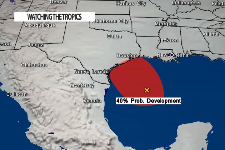
The National Hurricane Center is watching a disorganized area in the Gulf of Mexico – off the Texas coast for any development over the next 24 – 36 hours. Currently, they are giving this area a 40% probability of forming into a tropical depression. By the way – that’s up from 20% yesterday.
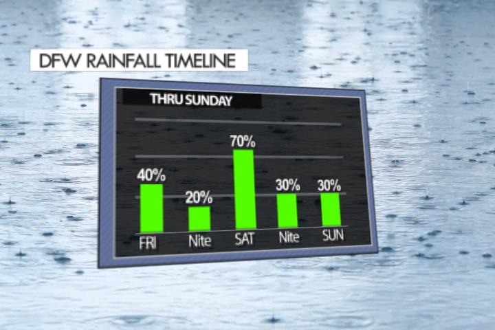
Spotty to scattered showers are possible today. However, rain is likely in several waves as we go through Saturday – so make your weekend plans accordingly!