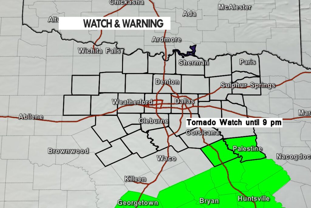
A Tornado Watch has been issued for our two far Southeastern Counties – Freestone and Anderson until 9 pm.
A Tornado Watch has been issued for our two far Southeastern Counties – Freestone and Anderson until 9 pm.

From William Cole: At 237 PM CDT, Doppler radar was tracking strong thunderstorms along a line extending from 6 miles northeast of Paris to near Scroggins. Movement was east at 30 mph. Half inch hail and winds in excess of 40 mph will be possible with these storms. Locations impacted include… Paris, Blossom, Deport and Sun Valley. LAT…LON 3297 9539 3380 9554 3386 9531 3298 9531 TIME…MOT…LOC 1937Z 263DEG 24KT 3374 9547 3295 9522
Stay with William Cole and Texas Weather Tracker TV for continuing coverage, online, on our app and on TV. Let’s stay safe together.

If you have not already downloaded the Free Texas Weather Tracker TV mobile app – do that now. Search your app store for Texas Weather Tracker TV. Also, add our free Live Channel to your TV through Roku, Apple or Amazon Fire TV streaming players.

Like our forecasts? Love our severe weather coverage? Help support us and local Texas weather coverage. Join our Patreon for $2.99 per month. www.patreon.com/texasweathertrackertv


From William Cole: A TORNADO WATCH has been issued in the Texas Weather Tracker TV coverage area for the following counties in North Texas until 9:00 PM Tuesday. Anderson.
We’ll have Live Severe Weather Coverage on the channel – which includes Texas’ #1 Storm Chasing Team – as needed. Be sure to download our free Texas Weather Tracker TV mobile app and add our Live channel to your Roku, Apple or Amazon Fire TV device.
Stay with William Cole and Texas Weather Tracker TV for continuing coverage, online, on our app and on TV. Let’s stay safe together.
From William Cole: At 206 PM CDT, Doppler radar was tracking strong thunderstorms along a line extending from Cooper Lake Park South Sulphur to near Pleasant Grove. Movement was east at 30 mph. Half inch hail and wind gusts up to 50 mph will be possible with these storms. Locations impacted include… Sulphur Springs, Cooper, Como, Deport, Cooper Lake Park South Sulphur, Cooper Lake Park Doctors Creek and Tira. LAT…LON 3296 9547 3337 9570 3363 9532 3361 9531 3296 9531 TIME…MOT…LOC 1906Z 271DEG 28KT 3330 9562 3298 9543
Stay with William Cole and Texas Weather Tracker TV for continuing coverage, online, on our app and on TV. Let’s stay safe together.
If you have not already downloaded the Free Texas Weather Tracker TV mobile app – do that now. Search your app store for Texas Weather Tracker TV. Also, add our free Live Channel to your TV through Roku, Apple or Amazon Fire TV streaming players.
Like our forecasts? Love our severe weather coverage? Help support us and local Texas weather coverage. Join our Patreon for $2.99 per month. www.patreon.com/texasweathertrackertv

Here’s a look at Live Temperatures across North Texas, MesoScan Radar and the Updated Forecast Map.
DFW THIS AFTERNOON…Showers and thunderstorms. Highs in the mid 70s. Southeast winds 10 to 15 mph. Chance of rain 90 percent. -William


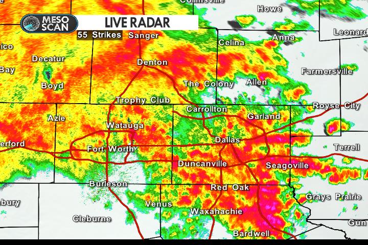
An area of heavy rain and vivid lighting is moving through the Metroplex. Watch for ponding and localized street flooding on area roads. Rain chances continue through the afternoon.

From the National Hurricane Center:
For the North Atlantic…Caribbean Sea and the Gulf of Mexico:
Tropical cyclone formation is not expected during the next 5 days.
$$ Forecaster Blake
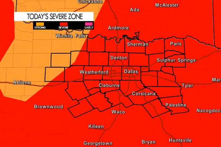
Heavy rain and flooding will be a concern today but also a few severe storms that pose a quarter to half dollar sized hail and winds to 60 mph threat – especially later this afternoon.
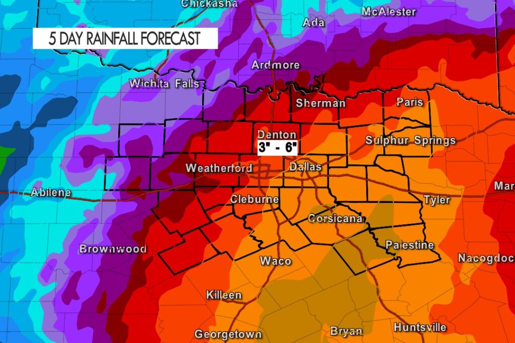
Rainfall projections especially today, tonight and tomorrow continue to look very impressive. Street and localized flooding may again become a concern. Remember, if you see standing water do not drive through it.
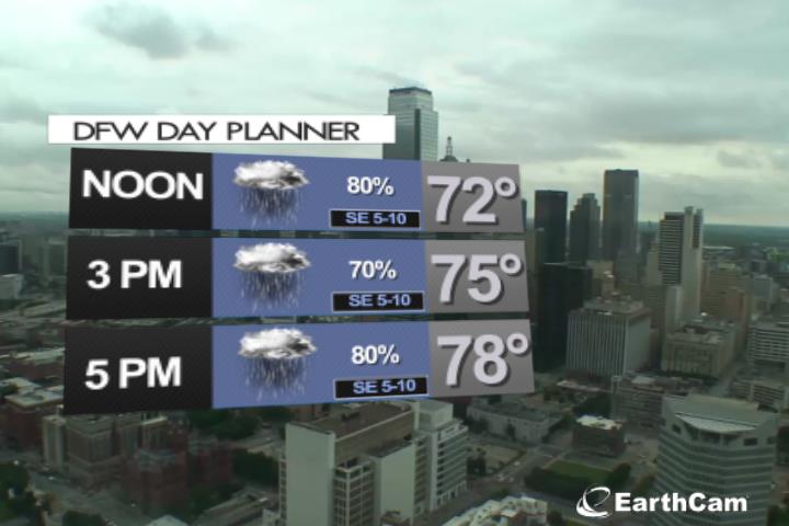
Expect a wet afternoon in the Metroplex with rain and storms building into the area. Temperatures stay rain cooled in the 70’s.