NOW Update Tuesday 8:59 AM: Parker, Tarrant & Wise Counties

Texas Weather Tracker TV Alert

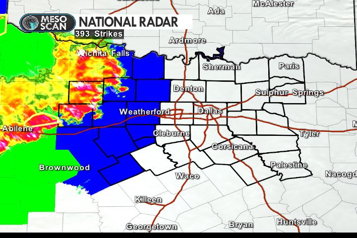
From William Cole: At 859 AM CDT, Doppler radar was tracking a strong thunderstorm over Reno, or near Briar, moving north at 20 mph. Nickel size hail and winds in excess of 40 mph will be possible with this storm. Locations impacted include… Azle, Briar, Eagle Mountain, Pecan Acres, Reno, Pelican Bay, Aurora, Rhome, Newark and Sanctuary. LAT…LON 3286 9753 3289 9769 3307 9762 3305 9742 TIME…MOT…LOC 1359Z 197DEG 16KT 3294 9757

Stay with William Cole and Texas Weather Tracker TV for continuing coverage, online, on our app and on TV. Let’s stay safe together.

Download App

If you have not already downloaded the Free Texas Weather Tracker TV mobile app – do that now. Search your app store for Texas Weather Tracker TV. Also, add our free Live Channel to your TV through Roku, Apple or Amazon Fire TV streaming players.

Streaming Servicet

Like our forecasts? Love our severe weather coverage? Help support us and local Texas weather coverage. Join our Patreon for $2.99 per month. www.patreon.com/texasweathertrackertv

Patreon

NOW Update Tuesday 7:59 AM: Denton & Tarrant Counties

Texas Weather Tracker TV Alert

From William Cole: At 759 AM CDT, Doppler radar was tracking a strong thunderstorm over Haltom City, moving north at 20 mph. Penny size hail will be possible with this storm. Locations impacted include… Fort Worth, Flower Mound, Bedford, Grapevine, Haltom City, Keller, Hurst, Southlake, Watauga, Colleyville, Saginaw, Trophy Club, Richland Hills, Sansom Park, Lake Worth, Eagle Mountain, North Richland Hills, Roanoke, Pecan Acres and Justin.

Stay with William Cole and Texas Weather Tracker TV for continuing coverage, online, on our app and on TV. Let’s stay safe together.

Download App

If you have not already downloaded the Free Texas Weather Tracker TV mobile app – do that now. Search your app store for Texas Weather Tracker TV. Also, add our free Live Channel to your TV through Roku, Apple or Amazon Fire TV streaming players.

Streaming Servicet

Like our forecasts? Love our severe weather coverage? Help support us and local Texas weather coverage. Join our Patreon for $2.99 per month. www.patreon.com/texasweathertrackertv

Patreon

ALERT 7:57 AM | Flood Advisory Tarrant County until 11:00 AM

Texas Weather Tracker TV Alert

From William Cole: A Flood Advisory has been issued for Tarrant County in the Metroplex until 11:00 AM. Ponding on the roadways and localized street flooding is possible.

At 757 AM CDT, Doppler radar and automated rain gauges indicated heavy rain due to thunderstorms. This will cause urban and small stream flooding. Areas that are low lying or poor drainage areas will experience minor flooding in the advisory area.

Remember if you see water across a roadway do not drive through it. Turn Around Don’t Drown.

Stay with William Cole and Texas Weather Tracker TV for continuing coverage, online, on our app and on TV. Let’s stay safe together.

Download App

If you have not already downloaded the Free Texas Weather Tracker TV mobile app – do that now. Search your app store for Texas Weather Tracker TV. Also, add our free Live Channel to your TV through Roku, Apple or Amazon Fire TV streaming players.

Streaming Servicet

Like our forecasts? Love our severe weather coverage? Help support us and local Texas weather coverage. Join our Patreon for $2.99 per month. www.patreon.com/texasweathertrackertv

Patreon

Overnight Update

Texas Weather Tracker TV Alert

Here’s a look at MesoScan Radar and Live Temperatures across North Texas.

DFW REST OF TONIGHT…A slight chance of showers and thunderstorms late this evening, then showers and thunderstorms. Lows in the upper 60s. Southeast winds 10 to 15 mph. Chance of rain 90 percent.

Texas Weather Tracker TV Alert

NOW Update Monday 11:13 PM: Erath County

Texas Weather Tracker TV Alert

From William Cole: At 1112 PM CDT, Doppler radar was tracking a strong thunderstorm near Huckabay, or 17 miles northwest of Stephenville, moving east at 35 mph. Penny size hail and wind gusts of 50 to 55 mph will be possible with this storm. Locations impacted include… Huckabay and Morgan Mill. A Severe Thunderstorm Watch remains in effect until 100 AM CDT for north central Texas. LAT…LON 3251 9847 3251 9807 3227 9796 3228 9805 3230 9847 TIME…MOT…LOC 0412Z 277DEG 29KT 3244 9835

Stay with William Cole and Texas Weather Tracker TV for continuing coverage, online, on our app and on TV. Let’s stay safe together.

Download App

If you have not already downloaded the Free Texas Weather Tracker TV mobile app – do that now. Search your app store for Texas Weather Tracker TV. Also, add our free Live Channel to your TV through Roku, Apple or Amazon Fire TV streaming players.

Streaming Servicet

Like our forecasts? Love our severe weather coverage? Help support us and local Texas weather coverage. Join our Patreon for $2.99 per month. www.patreon.com/texasweathertrackertv

Patreon

NOW Update Monday 10:01 PM: Stephens County

Texas Weather Tracker TV Alert

From William Cole: At 1001 PM CDT, Doppler radar was tracking a strong thunderstorm 7 miles north of Necessity, or 9 miles east of Breckenridge, moving east at 30 mph. Nickel size hail and wind gusts of 50 to 55 mph will be possible with this storm. Locations impacted include… Breckenridge, Necessity, Gunsight and Crystal Falls. A Severe Thunderstorm Watch remains in effect until 100 AM CDT for north central Texas. LAT…LON 3296 9909 3295 9858 3252 9858 3252 9910 TIME…MOT…LOC 0301Z 275DEG 26KT 3277 9875

Stay with William Cole and Texas Weather Tracker TV for continuing coverage, online, on our app and on TV. Let’s stay safe together.

Download App

If you have not already downloaded the Free Texas Weather Tracker TV mobile app – do that now. Search your app store for Texas Weather Tracker TV. Also, add our free Live Channel to your TV through Roku, Apple or Amazon Fire TV streaming players.

Streaming Servicet

Like our forecasts? Love our severe weather coverage? Help support us and local Texas weather coverage. Join our Patreon for $2.99 per month. www.patreon.com/texasweathertrackertv

Patreon

NOW Update Monday 9:23 PM: Stephens & Young Counties

Texas Weather Tracker TV Alert

From William Cole: At 922 PM CDT, Doppler radar was tracking a cluster of strong thunderstorms from near Olney to Breckenridge, moving east at 20 mph. Penny size hail and wind gusts of 50 to 55 mph will be possible with this storm. Locations impacted include… Graham, Breckenridge, Olney, Necessity, Gunsight, Crystal Falls, Newcastle and Us-180 Near The Shackelford-Stephens County Line. PRECAUTIONARY/PREPAREDNESS ACTIONS… Torrential rainfall is also occurring with this storm, and may lead to localized flooding. Do not drive your vehicle through flooded roadways. Frequent cloud to ground lightning is occurring with this storm. Seek a safe shelter inside a building or vehicle. &&

Stay with William Cole and Texas Weather Tracker TV for continuing coverage, online, on our app and on TV. Let’s stay safe together.

Download App

If you have not already downloaded the Free Texas Weather Tracker TV mobile app – do that now. Search your app store for Texas Weather Tracker TV. Also, add our free Live Channel to your TV through Roku, Apple or Amazon Fire TV streaming players.

Streaming Servicet

Like our forecasts? Love our severe weather coverage? Help support us and local Texas weather coverage. Join our Patreon for $2.99 per month. www.patreon.com/texasweathertrackertv

Patreon